Tocht Te voet Valbonne - Circuit des Macarons - Photo

Tous les sentiers balisés d’Europe GUIDE+
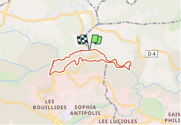
© OpenStreetMap contributors
Lengte
Lengte
6,3 km
Max. hoogte
Max. hoogte
210 m
Positief hoogteverschil
171 m
Km-Effort
Km-Effort  
8,6 km
Min. hoogte
Min. hoogte
73 m
Negatief hoogteverschil
172 m
Boucle
Boucle
Ja
Markering
Markering
Datum van aanmaak :
2022-02-15 00:25:00.642
Laatste wijziging :
2022-03-02 09:46:34.948

(0 Bericht)

Te voet
Te voet
1h57
Moeilijkheid : Gemakkelijk

Scan deze QR-code om de tocht te openen in de SityTrail-applicatie

Gratisgps-wandelapplicatie

Logo SityTrail SityTrail

IGN / Geografische instituten

SityTrail uit de App Store downloaden SityTrail uit Google Play downloaden

Logo SityTrail SityTrail Plus

De wereld gaat voor u open

SityTrail uit de App Store downloaden SityTrail uit Google Play downloaden SityTrail op Huawei AppGallery downloaden

Over ons

Tocht Te voet van 6,3 km beschikbaar op Provence-Alpes-Côte d'Azur, Alpes-Maritimes, Valbonne. Deze tocht wordt voorgesteld door SityTrail - itinéraires balisés pédestres.

Beschrijving

Trail created by Ville de Biot.


Website: https://www.biot-tourisme.com/fiches/circuit-des-macarons/

Hoogteprofiel

Foto's

Plaatsbepaling

Land:
France
Regio :
Provence-Alpes-Côte d'Azur
Departement/Provincie :
Alpes-Maritimes
Gemeente :
Valbonne
Locatie:
Unknown
Vertrek:(UTM)
342636 ; 4833134 (32T) N.


Sluiten
Mijn abonnementen