


Chemin Royal

SityTrail - itinéraires balisés pédestres
Tous les sentiers balisés d’Europe GUIDE+
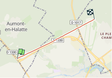

Lengte
3,5 km

Max. hoogte
96 m

Positief hoogteverschil
44 m
Km-Effort
4 km

Min. hoogte
73 m

Negatief hoogteverschil
29 m
Boucle
Neen

Markering
Datum van aanmaak :
2022-02-15 06:05:01.939
Laatste wijziging :
2022-03-02 14:39:29.274
54m
Moeilijkheid : Gemakkelijk

Gratisgps-wandelapplicatie
 SityTrail
IGN / Geografische instituten
SityTrail Plus
De wereld gaat voor u open
Over ons
Tocht Te voet van 3,5 km beschikbaar op Hauts-de-France, Oise, Aumont-en-Halatte. Deze tocht wordt voorgesteld door SityTrail - itinéraires balisés pédestres.
Foto's


Plaatsbepaling
Land:
France
Regio :
Hauts-de-France
Departement/Provincie :
Oise
Gemeente :
Aumont-en-Halatte
Locatie:
Unknown
Vertrek:(Dec)
Vertrek:(UTM)
467588 ; 5451744 (31U) N.
Opmerkingen