


elbeufjacky

doudet
Gebruiker
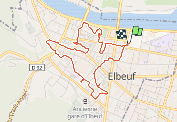

Lengte
5,3 km

Max. hoogte
26 m

Positief hoogteverschil
36 m
Km-Effort
5,7 km

Min. hoogte
7 m

Negatief hoogteverschil
35 m
Boucle
Ja
Datum van aanmaak :
2022-02-15 08:29:06.345
Laatste wijziging :
2022-02-15 10:40:53.871
2h11
Moeilijkheid : Gemakkelijk

Gratisgps-wandelapplicatie
 SityTrail
IGN / Geografische instituten
SityTrail Plus
De wereld gaat voor u open
Over ons
Tocht Stappen van 5,3 km beschikbaar op Normandië, Seine-Maritime, Elbeuf. Deze tocht wordt voorgesteld door doudet.
Plaatsbepaling
Land:
France
Regio :
Normandië
Departement/Provincie :
Seine-Maritime
Gemeente :
Elbeuf
Locatie:
Unknown
Vertrek:(Dec)
Vertrek:(UTM)
355480 ; 5461702 (31U) N.
Opmerkingen