


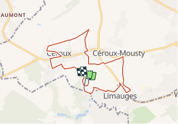
Promenade à Ottignies-Louvain-la-Neuve nᵒ 8 : Ferrières - Fontenelle

SityTrail - itinéraires balisés pédestres
Tous les sentiers balisés d’Europe GUIDE+


2h06
Moeilijkheid : Gemakkelijk

Gratisgps-wandelapplicatie
 SityTrail
IGN / Geografische instituten
SityTrail Plus
De wereld gaat voor u open
Over ons
Tocht Te voet van 8,1 km beschikbaar op Wallonië, Waals-Brabant, Ottignies-Louvain-la-Neuve. Deze tocht wordt voorgesteld door SityTrail - itinéraires balisés pédestres.
Beschrijving
Trail created by Ville d’Ottignies-Louvain-la-Neuve.
Website: http://www.tourisme-olln.be
Plaatsbepaling
Opmerkingen