Tocht Te voet Unknown - Byrtemannsbekken - Photo

Byrtemannsbekken

Tous les sentiers balisés d’Europe GUIDE+

© OpenStreetMap contributors
Lengte
Lengte
9,5 km
Max. hoogte
Max. hoogte
1049 m
Positief hoogteverschil
224 m
Km-Effort
Km-Effort  
12,4 km
Min. hoogte
Min. hoogte
843 m
Negatief hoogteverschil
201 m
Boucle
Boucle
Neen
Markering
Markering
Datum van aanmaak :
2022-02-21 10:15:20.638
Laatste wijziging :
2022-03-08 15:49:16.702

(0 Bericht)

Te voet
Te voet
2h48
Moeilijkheid : Gemakkelijk

Scan deze QR-code om de tocht te openen in de SityTrail-applicatie

Gratisgps-wandelapplicatie

Logo SityTrail SityTrail

IGN / Geografische instituten

SityTrail uit de App Store downloaden SityTrail uit Google Play downloaden

Logo SityTrail SityTrail Plus

De wereld gaat voor u open

SityTrail uit de App Store downloaden SityTrail uit Google Play downloaden SityTrail op Huawei AppGallery downloaden

Over ons

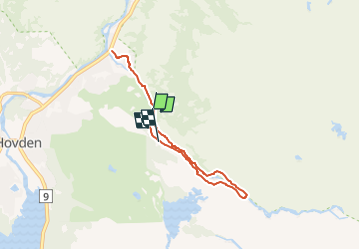
Tocht Te voet van 9,5 km beschikbaar op Agder. Deze tocht wordt voorgesteld door SityTrail - itinéraires balisés pédestres.

Beschrijving

Trail created by Destinasjon Hovden.

Symbol: markings with blue color on stones and trees


Website: https://hovden.com/

Hoogteprofiel

Plaatsbepaling

Land:
Norway
Regio :
Agder
Departement/Provincie :
Unknown
Gemeente :
Unknown
Locatie:
Unknown
Vertrek:(UTM)
409665 ; 6603855 (32V) N.


Sluiten
Mijn abonnementen