


Tentative 1, la source de Wislez

Koen van der Geest
Gebruiker
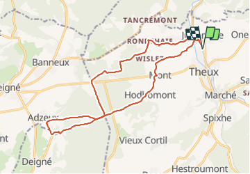

Lengte
17 km

Max. hoogte
348 m

Positief hoogteverschil
363 m
Km-Effort
22 km

Min. hoogte
155 m

Negatief hoogteverschil
363 m
Boucle
Ja
Datum van aanmaak :
2022-02-22 08:42:40.511
Laatste wijziging :
2022-02-22 11:12:08.529
2h23
Moeilijkheid : Heel gemakkelijk

Gratisgps-wandelapplicatie
 SityTrail
IGN / Geografische instituten
SityTrail Plus
De wereld gaat voor u open
Over ons
Tocht Lopen van 17 km beschikbaar op Wallonië, Luik, Theux. Deze tocht wordt voorgesteld door Koen van der Geest.
Plaatsbepaling
Land:
Belgium
Regio :
Wallonië
Departement/Provincie :
Luik
Gemeente :
Theux
Locatie:
Theux
Vertrek:(Dec)
Vertrek:(UTM)
699211 ; 5602724 (31U) N.
Opmerkingen