


2022-02-27_22h26m08_1645997102505_SityTrail - 3056792 - mont-saint-martin-mandelieu

verotrail
Gebruiker
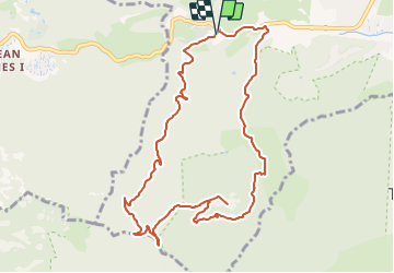

Lengte
11,2 km

Max. hoogte
371 m

Positief hoogteverschil
389 m
Km-Effort
16,4 km

Min. hoogte
16 m

Negatief hoogteverschil
387 m
Boucle
Ja
Datum van aanmaak :
2022-02-27 21:26:08.242
Laatste wijziging :
2022-02-27 21:26:06.01

Gratisgps-wandelapplicatie
 SityTrail
IGN / Geografische instituten
SityTrail Plus
De wereld gaat voor u open
Over ons
Tocht van 11,2 km beschikbaar op Provence-Alpes-Côte d'Azur, Alpes-Maritimes, Mandelieu-la-Napoule. Deze tocht wordt voorgesteld door verotrail.
Plaatsbepaling
Land:
France
Regio :
Provence-Alpes-Côte d'Azur
Departement/Provincie :
Alpes-Maritimes
Gemeente :
Mandelieu-la-Napoule
Locatie:
Unknown
Vertrek:(Dec)
Vertrek:(UTM)
330550 ; 4821197 (32T) N.
Opmerkingen