


Marche F.F.B.M.P. Aubel (16 kms)

NicolasWillem89
Gebruiker
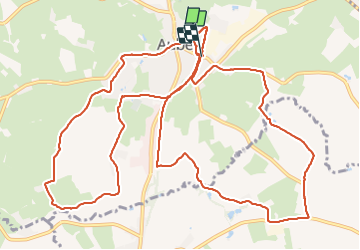

Lengte
16,3 km

Max. hoogte
250 m

Positief hoogteverschil
223 m
Km-Effort
19,3 km

Min. hoogte
182 m

Negatief hoogteverschil
212 m
Boucle
Neen
Datum van aanmaak :
2022-03-13 08:15:41.622
Laatste wijziging :
2022-03-13 11:09:43.26
2h33
Moeilijkheid : Zeer moeilijk

Gratisgps-wandelapplicatie
 SityTrail
IGN / Geografische instituten
SityTrail Plus
De wereld gaat voor u open
Over ons
Tocht Stappen van 16,3 km beschikbaar op Wallonië, Luik, Aubel. Deze tocht wordt voorgesteld door NicolasWillem89.
Beschrijving
Boucle B (8,5 kms) Boucle A (7 kms)
Plaatsbepaling
Land:
Belgium
Regio :
Wallonië
Departement/Provincie :
Luik
Gemeente :
Aubel
Locatie:
Unknown
Vertrek:(Dec)
Vertrek:(UTM)
701910 ; 5620886 (31U) N.
Opmerkingen