


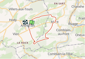
Anthisnes - Mont ( Comblain au Pont)

tatous
Gebruiker

Lengte
10,4 km

Max. hoogte
279 m

Positief hoogteverschil
204 m
Km-Effort
13,1 km

Min. hoogte
191 m

Negatief hoogteverschil
203 m
Boucle
Ja
Datum van aanmaak :
2022-03-13 16:22:48.844
Laatste wijziging :
2022-03-13 16:24:06.014
2h59
Moeilijkheid : Moeilijk

Gratisgps-wandelapplicatie
 SityTrail
IGN / Geografische instituten
SityTrail Plus
De wereld gaat voor u open
Over ons
Tocht Stappen van 10,4 km beschikbaar op Wallonië, Luik, Anthisnes. Deze tocht wordt voorgesteld door tatous.
Plaatsbepaling
Land:
Belgium
Regio :
Wallonië
Departement/Provincie :
Luik
Gemeente :
Anthisnes
Locatie:
Unknown
Vertrek:(Dec)
Vertrek:(UTM)
679081 ; 5595010 (31U) N.
Opmerkingen