


corbie versant gauche

NESTOR2714
Gebruiker
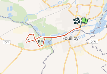

Lengte
5,6 km

Max. hoogte
43 m

Positief hoogteverschil
29 m
Km-Effort
6 km

Min. hoogte
26 m

Negatief hoogteverschil
29 m
Boucle
Ja
Datum van aanmaak :
2022-03-20 10:53:33.831
Laatste wijziging :
2022-03-20 10:57:48.29
41m
Moeilijkheid : Gemakkelijk

Gratisgps-wandelapplicatie
 SityTrail
IGN / Geografische instituten
SityTrail Plus
De wereld gaat voor u open
Over ons
Tocht Te voet van 5,6 km beschikbaar op Hauts-de-France, Somme, Corbie. Deze tocht wordt voorgesteld door NESTOR2714.
Plaatsbepaling
Land:
France
Regio :
Hauts-de-France
Departement/Provincie :
Somme
Gemeente :
Corbie
Locatie:
Unknown
Vertrek:(Dec)
Vertrek:(UTM)
464785 ; 5528170 (31U) N.
Opmerkingen