


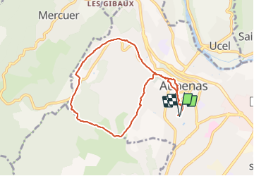
Les Oliviers-Roche noire-Lazuel 21/03/22

Linerou
Gebruiker

Lengte
8,3 km

Max. hoogte
422 m

Positief hoogteverschil
238 m
Km-Effort
11,5 km

Min. hoogte
234 m

Negatief hoogteverschil
240 m
Boucle
Ja
Datum van aanmaak :
2022-03-21 08:09:04.504
Laatste wijziging :
2022-03-21 10:55:18.606
2h26
Moeilijkheid : Gemakkelijk

Gratisgps-wandelapplicatie
 SityTrail
IGN / Geografische instituten
SityTrail Plus
De wereld gaat voor u open
Over ons
Tocht Stappen van 8,3 km beschikbaar op Auvergne-Rhône-Alpes, Ardèche, Aubenas. Deze tocht wordt voorgesteld door Linerou.
Plaatsbepaling
Land:
France
Regio :
Auvergne-Rhône-Alpes
Departement/Provincie :
Ardèche
Gemeente :
Aubenas
Locatie:
Unknown
Vertrek:(Dec)
Vertrek:(UTM)
610229 ; 4941157 (31T) N.
Opmerkingen