


TMV2022 - Etape 2

Vacs
Gebruiker
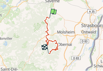

Lengte
73 km

Max. hoogte
828 m

Positief hoogteverschil
2262 m
Km-Effort
102 km

Min. hoogte
231 m

Negatief hoogteverschil
2005 m
Boucle
Neen
Datum van aanmaak :
2022-03-22 20:21:45.434
Laatste wijziging :
2022-04-20 11:22:15.028
1h03
Moeilijkheid : Gemakkelijk

Gratisgps-wandelapplicatie
 SityTrail
IGN / Geografische instituten
SityTrail Plus
De wereld gaat voor u open
Over ons
Tocht Mountainbike van 73 km beschikbaar op Grand Est, Bas-Rhin, Wangenbourg-Engenthal. Deze tocht wordt voorgesteld door Vacs.
Plaatsbepaling
Land:
France
Regio :
Grand Est
Departement/Provincie :
Bas-Rhin
Gemeente :
Wangenbourg-Engenthal
Locatie:
Unknown
Vertrek:(Dec)
Vertrek:(UTM)
377308 ; 5387724 (32U) N.
Opmerkingen