Gavray 8,5 km

coglais
Gebruiker
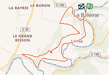

Lengte
6 km

Max. hoogte
103 m

Positief hoogteverschil
156 m
Km-Effort
8,1 km

Min. hoogte
39 m

Negatief hoogteverschil
155 m
Boucle
Ja
Datum van aanmaak :
2022-03-23 08:48:49.892
Laatste wijziging :
2022-05-02 09:50:43.61
1h56
Moeilijkheid : Heel gemakkelijk

Gratisgps-wandelapplicatie
 SityTrail
IGN / Geografische instituten
SityTrail Plus
De wereld gaat voor u open
Over ons
Tocht Noords wandelen van 6 km beschikbaar op Normandië, Manche, La Baleine. Deze tocht wordt voorgesteld door coglais.
Plaatsbepaling
Land:
France
Regio :
Normandië
Departement/Provincie :
Manche
Gemeente :
La Baleine
Locatie:
Unknown
Vertrek:(Dec)
Vertrek:(UTM)
623263 ; 5420489 (30U) N.
Opmerkingen