


GR016-Parcours-principal_2021-03-24

binches
Gebruiker
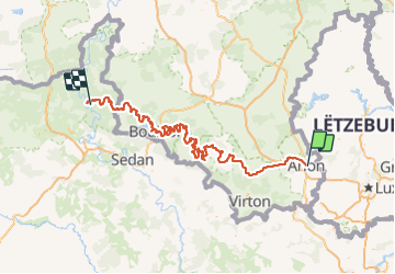

Lengte
209 km

Max. hoogte
451 m

Positief hoogteverschil
5264 m
Km-Effort
280 km

Min. hoogte
137 m

Negatief hoogteverschil
5522 m
Boucle
Neen
Datum van aanmaak :
2022-04-04 10:25:35.0
Laatste wijziging :
2022-04-04 10:25:38.106

Gratisgps-wandelapplicatie
 SityTrail
IGN / Geografische instituten
SityTrail Plus
De wereld gaat voor u open
Over ons
Tocht van 209 km beschikbaar op Wallonië, Luxemburg, Aarlen. Deze tocht wordt voorgesteld door binches.
Plaatsbepaling
Land:
Belgium
Regio :
Wallonië
Departement/Provincie :
Luxemburg
Gemeente :
Aarlen
Locatie:
Aarlen
Vertrek:(Dec)
Vertrek:(UTM)
703438 ; 5507051 (31U) N.
Opmerkingen