


cel

Tollard
Gebruiker

Lengte
49 km

Max. hoogte
322 m

Positief hoogteverschil
1035 m
Km-Effort
63 km

Min. hoogte
146 m

Negatief hoogteverschil
1039 m
Boucle
Ja
Datum van aanmaak :
2014-12-10 00:00:00.0
Laatste wijziging :
2014-12-10 00:00:00.0
4h09
Moeilijkheid : Moeilijk

Gratisgps-wandelapplicatie
 SityTrail
IGN / Geografische instituten
SityTrail Plus
De wereld gaat voor u open
Over ons
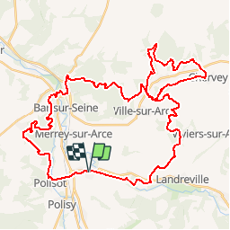
Tocht Mountainbike van 49 km beschikbaar op Grand Est, Aube, Celles-sur-Ource. Deze tocht wordt voorgesteld door Tollard.
Plaatsbepaling
Land:
France
Regio :
Grand Est
Departement/Provincie :
Aube
Gemeente :
Celles-sur-Ource
Locatie:
Unknown
Vertrek:(Dec)
Vertrek:(UTM)
604411 ; 5325759 (31U) N.
Opmerkingen