


Cobac 14 - 04 - 2022

nolsim
Gebruiker

Lengte
12,4 km

Max. hoogte
93 m

Positief hoogteverschil
100 m
Km-Effort
13,7 km

Min. hoogte
49 m

Negatief hoogteverschil
104 m
Boucle
Neen
Datum van aanmaak :
2022-04-14 12:30:59.803
Laatste wijziging :
2022-04-14 15:21:11.425
2h28
Moeilijkheid : Gemakkelijk

Gratisgps-wandelapplicatie
 SityTrail
IGN / Geografische instituten
SityTrail Plus
De wereld gaat voor u open
Over ons
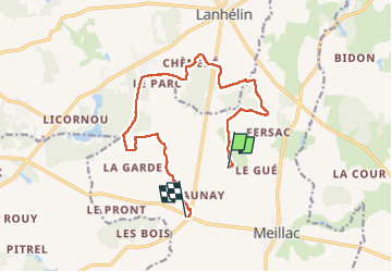
Tocht Stappen van 12,4 km beschikbaar op Bretagne, Ille-et-Vilaine, Meillac. Deze tocht wordt voorgesteld door nolsim.
Plaatsbepaling
Land:
France
Regio :
Bretagne
Departement/Provincie :
Ille-et-Vilaine
Gemeente :
Meillac
Locatie:
Unknown
Vertrek:(Dec)
Vertrek:(UTM)
586778 ; 5364252 (30U) N.
Opmerkingen