


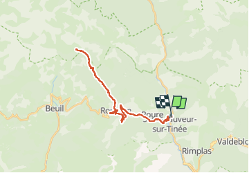
Vignols en partant de St Sauveur sur Tinée

franquen
Gebruiker

Lengte
36 km

Max. hoogte
1641 m

Positief hoogteverschil
1498 m
Km-Effort
56 km

Min. hoogte
505 m

Negatief hoogteverschil
1521 m
Boucle
Neen
Datum van aanmaak :
2022-04-18 08:41:23.203
Laatste wijziging :
2022-04-18 17:10:13.2
4h00
Moeilijkheid : Gemakkelijk

Gratisgps-wandelapplicatie
 SityTrail
IGN / Geografische instituten
SityTrail Plus
De wereld gaat voor u open
Over ons
Tocht Elektrische fiets van 36 km beschikbaar op Provence-Alpes-Côte d'Azur, Alpes-Maritimes, Saint-Sauveur-sur-Tinée. Deze tocht wordt voorgesteld door franquen.
Beschrijving
Belle balade en pente régulière avec une pause resto à Roubion au retour (auberge du Moulin)
Plaatsbepaling
Land:
France
Regio :
Provence-Alpes-Côte d'Azur
Departement/Provincie :
Alpes-Maritimes
Gemeente :
Saint-Sauveur-sur-Tinée
Locatie:
Unknown
Vertrek:(Dec)
Vertrek:(UTM)
348250 ; 4883370 (32T) N.
Opmerkingen