


Le village

topnature !
Gebruiker

Lengte
4,7 km

Max. hoogte
263 m

Positief hoogteverschil
71 m
Km-Effort
5,7 km

Min. hoogte
225 m

Negatief hoogteverschil
75 m
Boucle
Ja
Datum van aanmaak :
2022-04-30 12:32:04.0
Laatste wijziging :
2022-04-30 13:46:42.885
1h11
Moeilijkheid : Gemakkelijk

Gratisgps-wandelapplicatie
 SityTrail
IGN / Geografische instituten
SityTrail Plus
De wereld gaat voor u open
Over ons
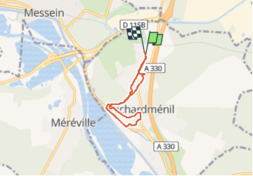
Tocht Stappen van 4,7 km beschikbaar op Grand Est, Meurthe-et-Moselle, Richardménil. Deze tocht wordt voorgesteld door topnature !.
Beschrijving
Dans Richardmenil
Plaatsbepaling
Land:
France
Regio :
Grand Est
Departement/Provincie :
Meurthe-et-Moselle
Gemeente :
Richardménil
Locatie:
Unknown
Vertrek:(Dec)
Vertrek:(UTM)
291401 ; 5387210 (32U) N.
Opmerkingen