


Hastier
© OpenStreetMap contributors


4h33
Moeilijkheid : Zeer moeilijk


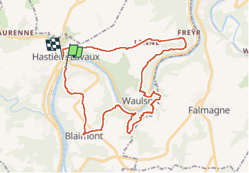
Lengte
18,8 km
Max. hoogte
249 m
Positief hoogteverschil
538 m
Km-Effort
26 km
Min. hoogte
94 m
Negatief hoogteverschil
535 m
Boucle
Neen
Datum van aanmaak :
2022-05-01 09:16:45.0
Laatste wijziging :
2022-05-01 14:43:36.927
4h33
Moeilijkheid : Zeer moeilijk
Gratisgps-wandelapplicatie
 SityTrail
IGN / Geografische instituten
SityTrail Plus
De wereld gaat voor u open
Over ons
Tocht Stappen van 18,8 km beschikbaar op Wallonië, Namen, Hastière. Deze tocht wordt voorgesteld door 001433.7bed7ed0214a4463aa3b337c51a300eb.1151.
Plaatsbepaling
Land:
Belgium
Regio :
Wallonië
Departement/Provincie :
Namen
Gemeente :
Hastière
Locatie:
Unknown
Vertrek:(Dec)
Vertrek:(UTM)
630274 ; 5564031 (31U) N.
Opmerkingen