


Bel Com chez

Nono55
Gebruiker
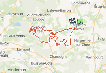

Lengte
46 km

Max. hoogte
251 m

Positief hoogteverschil
582 m
Km-Effort
54 km

Min. hoogte
176 m

Negatief hoogteverschil
582 m
Boucle
Ja
Datum van aanmaak :
2022-05-15 06:48:32.0
Laatste wijziging :
2022-05-15 19:28:58.604
3h25
Moeilijkheid : Onbekend

Gratisgps-wandelapplicatie
 SityTrail
IGN / Geografische instituten
SityTrail Plus
De wereld gaat voor u open
Over ons
Tocht Mountainbike van 46 km beschikbaar op Grand Est, Meuse, Les Hauts-de-Chée. Deze tocht wordt voorgesteld door Nono55.
Beschrijving
Sortie organisation au top
Single track a foison
Pas dur
Temps au top
Plaatsbepaling
Land:
France
Regio :
Grand Est
Departement/Provincie :
Meuse
Gemeente :
Les Hauts-de-Chée
Locatie:
Unknown
Vertrek:(Dec)
Vertrek:(UTM)
658904 ; 5415042 (31U) N.
Opmerkingen