


Au-dessous de Gordes : Les Imberts - 13208 - UtagawaVTT.com

denel
Gebruiker

Lengte
47 km

Max. hoogte
331 m

Positief hoogteverschil
1052 m
Km-Effort
61 km

Min. hoogte
84 m

Negatief hoogteverschil
1056 m
Boucle
Ja
Datum van aanmaak :
2022-05-17 16:46:57.184
Laatste wijziging :
2023-02-09 18:06:27.751
4h10
Moeilijkheid : Medium

Gratisgps-wandelapplicatie
 SityTrail
IGN / Geografische instituten
SityTrail Plus
De wereld gaat voor u open
Over ons
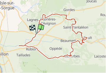
Tocht Mountainbike van 47 km beschikbaar op Provence-Alpes-Côte d'Azur, Vaucluse, Robion. Deze tocht wordt voorgesteld door denel.
Beschrijving
Départ possible du Mas Honorat
Plaatsbepaling
Land:
France
Regio :
Provence-Alpes-Côte d'Azur
Departement/Provincie :
Vaucluse
Gemeente :
Robion
Locatie:
Unknown
Vertrek:(Dec)
Vertrek:(UTM)
670766 ; 4859632 (31T) N.
Opmerkingen