


Altschlossfelsen

noelphil
Gebruiker
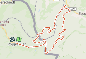

Lengte
14,2 km

Max. hoogte
412 m

Positief hoogteverschil
370 m
Km-Effort
19,1 km

Min. hoogte
284 m

Negatief hoogteverschil
370 m
Boucle
Ja
Datum van aanmaak :
2022-05-20 12:13:56.516
Laatste wijziging :
2024-05-14 14:08:02.397
4h49
Moeilijkheid : Zeer moeilijk

Gratisgps-wandelapplicatie
 SityTrail
IGN / Geografische instituten
SityTrail Plus
De wereld gaat voor u open
Over ons
Tocht Stappen van 14,2 km beschikbaar op Grand Est, Moselle, Roppeviller. Deze tocht wordt voorgesteld door noelphil.
Plaatsbepaling
Land:
France
Regio :
Grand Est
Departement/Provincie :
Moselle
Gemeente :
Roppeviller
Locatie:
Unknown
Vertrek:(Dec)
Vertrek:(UTM)
391070 ; 5439781 (32U) N.
Opmerkingen