


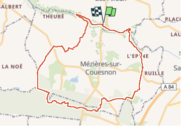
St Ouen Des Alleux Pkg La Coursonnière-Forêt de St Aubin (Zone humide) 21km JY

COGLAIS3
Gebruiker

Lengte
21 km

Max. hoogte
117 m

Positief hoogteverschil
274 m
Km-Effort
25 km

Min. hoogte
43 m

Negatief hoogteverschil
275 m
Boucle
Ja
Datum van aanmaak :
2022-05-24 06:08:35.448
Laatste wijziging :
2022-05-25 19:49:45.974
3h57
Moeilijkheid : Gemakkelijk

Gratisgps-wandelapplicatie
 SityTrail
IGN / Geografische instituten
SityTrail Plus
De wereld gaat voor u open
Over ons
Tocht Noords wandelen van 21 km beschikbaar op Bretagne, Ille-et-Vilaine, Saint-Ouen-des-Alleux. Deze tocht wordt voorgesteld door COGLAIS3.
Plaatsbepaling
Land:
France
Regio :
Bretagne
Departement/Provincie :
Ille-et-Vilaine
Gemeente :
Saint-Ouen-des-Alleux
Locatie:
Unknown
Vertrek:(Dec)
Vertrek:(UTM)
616372 ; 5352502 (30U) N.
Opmerkingen