


maissin-our-redu-lesse

thomas1986
Gebruiker
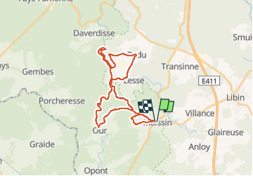

Lengte
28 km

Max. hoogte
407 m

Positief hoogteverschil
556 m
Km-Effort
36 km

Min. hoogte
250 m

Negatief hoogteverschil
554 m
Boucle
Ja
Datum van aanmaak :
2022-05-26 08:43:28.729
Laatste wijziging :
2022-05-26 11:25:50.716
2h20
Moeilijkheid : Moeilijk

Gratisgps-wandelapplicatie
 SityTrail
IGN / Geografische instituten
SityTrail Plus
De wereld gaat voor u open
Over ons
Tocht Mountainbike van 28 km beschikbaar op Wallonië, Luxemburg, Paliseul. Deze tocht wordt voorgesteld door thomas1986.
Plaatsbepaling
Land:
Belgium
Regio :
Wallonië
Departement/Provincie :
Luxemburg
Gemeente :
Paliseul
Locatie:
Unknown
Vertrek:(Dec)
Vertrek:(UTM)
656326 ; 5537082 (31U) N.
Opmerkingen