


Fleville

topnature !
Gebruiker

Lengte
15,7 km

Max. hoogte
287 m

Positief hoogteverschil
220 m
Km-Effort
18,6 km

Min. hoogte
208 m

Negatief hoogteverschil
189 m
Boucle
Neen
Datum van aanmaak :
2022-05-30 12:12:18.0
Laatste wijziging :
2022-05-30 18:40:54.453
3h00
Moeilijkheid : Gemakkelijk

Gratisgps-wandelapplicatie
 SityTrail
IGN / Geografische instituten
SityTrail Plus
De wereld gaat voor u open
Over ons
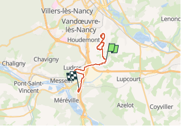
Tocht Stappen van 15,7 km beschikbaar op Grand Est, Meurthe-et-Moselle, Fléville-devant-Nancy. Deze tocht wordt voorgesteld door topnature !.
Beschrijving
Le bois des Fourneaux
Plaatsbepaling
Land:
France
Regio :
Grand Est
Departement/Provincie :
Meurthe-et-Moselle
Gemeente :
Fléville-devant-Nancy
Locatie:
Unknown
Vertrek:(Dec)
Vertrek:(UTM)
294237 ; 5389957 (32U) N.
Opmerkingen