


14677595-VTT CHATENOIS ANDLAU

nicolas54230
Gebruiker
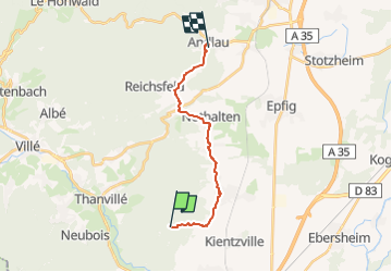

Lengte
13,7 km

Max. hoogte
447 m

Positief hoogteverschil
284 m
Km-Effort
18,2 km

Min. hoogte
204 m

Negatief hoogteverschil
504 m
Boucle
Neen
Datum van aanmaak :
2022-06-17 16:41:06.251
Laatste wijziging :
2022-06-17 16:41:28.087
1h15
Moeilijkheid : Gemakkelijk

Gratisgps-wandelapplicatie
 SityTrail
IGN / Geografische instituten
SityTrail Plus
De wereld gaat voor u open
Over ons
Tocht Mountainbike van 13,7 km beschikbaar op Grand Est, Bas-Rhin, Scherwiller. Deze tocht wordt voorgesteld door nicolas54230.
Plaatsbepaling
Land:
France
Regio :
Grand Est
Departement/Provincie :
Bas-Rhin
Gemeente :
Scherwiller
Locatie:
Unknown
Vertrek:(Dec)
Vertrek:(UTM)
380940 ; 5351856 (32U) N.
Opmerkingen