


Les Tines - Argentières AR 12,5 km

jeanmarcMasson
Gebruiker GUIDE
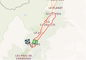

Lengte
12,8 km

Max. hoogte
1324 m

Positief hoogteverschil
395 m
Km-Effort
18 km

Min. hoogte
1081 m

Negatief hoogteverschil
398 m
Boucle
Ja
Datum van aanmaak :
2022-06-28 07:01:04.461
Laatste wijziging :
2022-07-03 06:50:33.115
3h18
Moeilijkheid : Moeilijk

Gratisgps-wandelapplicatie
 SityTrail
IGN / Geografische instituten
SityTrail Plus
De wereld gaat voor u open
Over ons
Tocht Stappen van 12,8 km beschikbaar op Auvergne-Rhône-Alpes, Haute-Savoie, Chamonix-Mont-Blanc. Deze tocht wordt voorgesteld door jeanmarcMasson.
Plaatsbepaling
Land:
France
Regio :
Auvergne-Rhône-Alpes
Departement/Provincie :
Haute-Savoie
Gemeente :
Chamonix-Mont-Blanc
Locatie:
Unknown
Vertrek:(Dec)
Vertrek:(UTM)
337175 ; 5090661 (32T) N.
Opmerkingen