


Falaën ADEPS

thomarche
Gebruiker
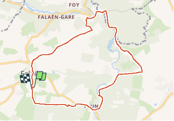

Lengte
9,8 km

Max. hoogte
246 m

Positief hoogteverschil
240 m
Km-Effort
13 km

Min. hoogte
126 m

Negatief hoogteverschil
243 m
Boucle
Ja
Datum van aanmaak :
2022-07-03 12:09:07.0
Laatste wijziging :
2022-07-03 14:36:21.393
2h26
Moeilijkheid : Heel gemakkelijk

Gratisgps-wandelapplicatie
 SityTrail
IGN / Geografische instituten
SityTrail Plus
De wereld gaat voor u open
Over ons
Tocht Stappen van 9,8 km beschikbaar op Wallonië, Namen, Onhaye. Deze tocht wordt voorgesteld door thomarche.
Beschrijving
Boucle avc macadam peu fréquenté. Très beau village tout en pierres. ruines château Montaigle sentier long Flavion.
Plaatsbepaling
Land:
Belgium
Regio :
Wallonië
Departement/Provincie :
Namen
Gemeente :
Onhaye
Locatie:
Unknown
Vertrek:(Dec)
Vertrek:(UTM)
627862 ; 5570768 (31U) N.
Opmerkingen