


J4 TMV

lorenzot54
Gebruiker
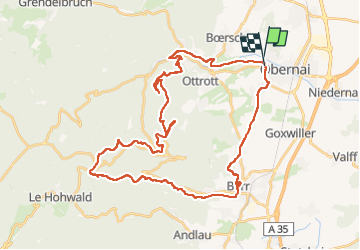

Lengte
43 km

Max. hoogte
828 m

Positief hoogteverschil
1153 m
Km-Effort
59 km

Min. hoogte
194 m

Negatief hoogteverschil
1155 m
Boucle
Neen
Datum van aanmaak :
2022-07-14 06:01:48.0
Laatste wijziging :
2022-07-14 16:24:23.009
7h27
Moeilijkheid : Zeer moeilijk

Gratisgps-wandelapplicatie
 SityTrail
IGN / Geografische instituten
SityTrail Plus
De wereld gaat voor u open
Over ons
Tocht Mountainbike van 43 km beschikbaar op Grand Est, Bas-Rhin, Obernai. Deze tocht wordt voorgesteld door lorenzot54.
Plaatsbepaling
Land:
France
Regio :
Grand Est
Departement/Provincie :
Bas-Rhin
Gemeente :
Obernai
Locatie:
Unknown
Vertrek:(Dec)
Vertrek:(UTM)
386656 ; 5369283 (32U) N.
Opmerkingen