


Entre Lesse & Lomme

Christophe Borgniet
Gebruiker
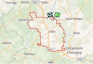

Lengte
80 km

Max. hoogte
498 m

Positief hoogteverschil
1821 m
Km-Effort
104 km

Min. hoogte
215 m

Negatief hoogteverschil
1812 m
Boucle
Ja
Datum van aanmaak :
2022-07-23 06:54:28.896
Laatste wijziging :
2022-07-23 07:02:22.222
23h37
Moeilijkheid : Zeer moeilijk

Gratisgps-wandelapplicatie
 SityTrail
IGN / Geografische instituten
SityTrail Plus
De wereld gaat voor u open
Over ons
Tocht Te voet van 80 km beschikbaar op Wallonië, Luxemburg, Libin. Deze tocht wordt voorgesteld door Christophe Borgniet.

Plaatsbepaling
Land:
Belgium
Regio :
Wallonië
Departement/Provincie :
Luxemburg
Gemeente :
Libin
Locatie:
Unknown
Vertrek:(Dec)
Vertrek:(UTM)
662305 ; 5543210 (31U) N.
Opmerkingen
