


saint sebastien d'aigrefeuille

guariso
Gebruiker
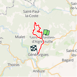

Lengte
15,3 km

Max. hoogte
451 m

Positief hoogteverschil
321 m
Km-Effort
19,7 km

Min. hoogte
159 m

Negatief hoogteverschil
351 m
Boucle
Neen
Datum van aanmaak :
2014-12-10 00:00:00.0
Laatste wijziging :
2014-12-10 00:00:00.0
4h20
Moeilijkheid : Medium

Gratisgps-wandelapplicatie
 SityTrail
IGN / Geografische instituten
SityTrail Plus
De wereld gaat voor u open
Over ons
Tocht Stappen van 15,3 km beschikbaar op Occitanië, Gard, Saint-Sébastien-d'Aigrefeuille. Deze tocht wordt voorgesteld door guariso.
Plaatsbepaling
Land:
France
Regio :
Occitanië
Departement/Provincie :
Gard
Gemeente :
Saint-Sébastien-d'Aigrefeuille
Locatie:
Unknown
Vertrek:(Dec)
Vertrek:(UTM)
579526 ; 4884237 (31T) N.
Opmerkingen