


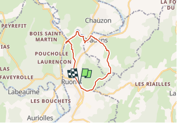
2022-08-12_09h23m03_2022-08-12_883146252_GPX Download_ Rapide de pradons – l'Ardèche à Ruoms Circuit à partir de Ruoms

Linerou
Gebruiker

Lengte
10,6 km

Max. hoogte
257 m

Positief hoogteverschil
301 m
Km-Effort
14,7 km

Min. hoogte
111 m

Negatief hoogteverschil
301 m
Boucle
Ja
Datum van aanmaak :
2022-08-12 07:23:03.516
Laatste wijziging :
2022-08-12 07:23:04.987

Gratisgps-wandelapplicatie
 SityTrail
IGN / Geografische instituten
SityTrail Plus
De wereld gaat voor u open
Over ons
Tocht van 10,6 km beschikbaar op Auvergne-Rhône-Alpes, Ardèche, Ruoms. Deze tocht wordt voorgesteld door Linerou.
Plaatsbepaling
Land:
France
Regio :
Auvergne-Rhône-Alpes
Departement/Provincie :
Ardèche
Gemeente :
Ruoms
Locatie:
Unknown
Vertrek:(Dec)
Vertrek:(UTM)
607106 ; 4923003 (31T) N.
Opmerkingen