Tocht Stappen Bolquère - 2022 TRANSPYRÉNÉENNE ; Superbolquère - refuge de la Carança - Photo

2022 TRANSPYRÉNÉENNE ; Superbolquère - refuge de la Carança

 LEGUE
LEGUE

Gebruiker

© OpenStreetMap contributors
Lengte
Lengte
31 km
Max. hoogte
Max. hoogte
2387 m
Positief hoogteverschil
1378 m
Km-Effort
Km-Effort  
50 km
Min. hoogte
Min. hoogte
1475 m
Negatief hoogteverschil
1324 m
Boucle
Boucle
Neen
Datum van aanmaak :
2022-08-19 06:18:26.0
Laatste wijziging :
2022-08-20 07:38:19.249

(0 Bericht)

Stappen
Stappen
7h30
Moeilijkheid : Zeer moeilijk

Scan deze QR-code om de tocht te openen in de SityTrail-applicatie

Gratisgps-wandelapplicatie

Logo SityTrail SityTrail

IGN / Geografische instituten

SityTrail uit de App Store downloaden SityTrail uit Google Play downloaden

Logo SityTrail SityTrail World

De wereld gaat voor u open

SityTrail uit de App Store downloaden SityTrail uit Google Play downloaden SityTrail op Huawei AppGallery downloaden

Over ons

Tocht Stappen van 31 km beschikbaar op Occitanië, Pyrénées-Orientales, Bolquère. Deze tocht wordt voorgesteld door LEGUE.

Beschrijving

30km

Hoogteprofiel

Foto's

Plaatsbepaling

Land:
France
Regio :
Occitanië
Departement/Provincie :
Pyrénées-Orientales
Gemeente :
Bolquère
Locatie:
Unknown
Vertrek:(Dec)
Vertrek:(UTM)
422877 ; 4707314 (31T) N.

Wandeltochten in de omgeving

Tocht Stappen Font-Romeu-Odeillo-Via - Coll del Pam lac des  Bouillouses - Photo
Stappen
jcmartin

Stappen

Medium
(2)
Font-Romeu-Odeillo-Via, Occitanië, Pyrénées-Orientales, France
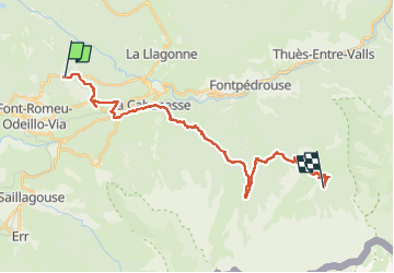
13,3 km | 19,3 km-effort
4h 10min
Ja
Tocht Stappen Eyne - Eyne,col de Nuria,pic d'Eyne,Torre d'Eyne,Eyne. - Photo
Stappen
Machaon6

Stappen

Zeer moeilijk
(1)
Eyne, Occitanië, Pyrénées-Orientales, France
24 km | 43 km-effort
8h 44min
Ja
Tocht Sneeuwschoenen Font-Romeu-Odeillo-Via - pic dels moros - Photo
Sneeuwschoenen
jpipacific

Sneeuwschoenen

Medium
(1)
Font-Romeu-Odeillo-Via, Occitanië, Pyrénées-Orientales, France
12,6 km | 19,4 km-effort
4h 46min
Ja
Tocht Stappen Les Angles - Rando des 12 lacs - Photo
Stappen
stp130678

Stappen

Gemakkelijk
(1)
Les Angles, Occitanië, Pyrénées-Orientales, France
14,1 km | 20 km-effort
6h 30min
Ja
Tocht Stappen Font-Romeu-Odeillo-Via - Font Romeu Egat - Photo
Stappen
crijack

Stappen

Medium
(2)
Font-Romeu-Odeillo-Via, Occitanië, Pyrénées-Orientales, France
2,5 km | 3,4 km-effort
44min
Ja
Tocht Sneeuwschoenen Font-Romeu-Odeillo-Via - Pic dels Moros avec Pierre - Photo
Sneeuwschoenen
jpipacific

Sneeuwschoenen

Medium
(1)
Font-Romeu-Odeillo-Via, Occitanië, Pyrénées-Orientales, France
10,5 km | 15,9 km-effort
4h 4min
Ja
Tocht Stappen Égat - Egat  Puig  Moro - Photo
Stappen
ohelluin

Stappen

Medium
(1)
Égat, Occitanië, Pyrénées-Orientales, France
13,4 km | 19,3 km-effort
4h 51min
Ja
Tocht Stappen Égat - La croix d'Egat - Photo
Stappen
ochamley

Stappen

Gemakkelijk
(1)
Égat, Occitanië, Pyrénées-Orientales, France
7,1 km | 10,4 km-effort
2h 2min
Ja
Tocht Stappen Égat - Le Pic dels Moros - Photo
Stappen
tracegps

Stappen

Moeilijk
(2)
Égat, Occitanië, Pyrénées-Orientales, France
12,1 km | 18,8 km-effort
5h 30min
Ja


Sluiten
Mijn abonnementen