


SorinneLL Bizonzon Bethleem Sous le Pourrain

thomarche
Gebruiker

Lengte
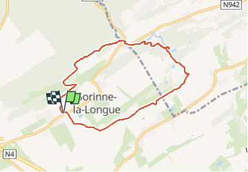
7,3 km

Max. hoogte
275 m

Positief hoogteverschil
143 m
Km-Effort
9,2 km

Min. hoogte
189 m

Negatief hoogteverschil
142 m
Boucle
Ja
Datum van aanmaak :
2022-08-26 12:54:39.0
Laatste wijziging :
2024-12-12 11:12:30.082
2h39
Moeilijkheid : Onbekend

Gratisgps-wandelapplicatie
 SityTrail
IGN / Geografische instituten
SityTrail Plus
De wereld gaat voor u open
Over ons
Tocht Stappen van 7,3 km beschikbaar op Wallonië, Namen, Assesse. Deze tocht wordt voorgesteld door thomarche.
Beschrijving
Magnifique boucle par champs et bois. Varié, hyper calme, vues, très beaux arbres sur le parcours, très peu de macadam et non fréquenté.
Plaatsbepaling
Land:
Belgium
Regio :
Wallonië
Departement/Provincie :
Namen
Gemeente :
Assesse
Locatie:
Unknown
Vertrek:(Dec)
Vertrek:(UTM)
643686 ; 5583723 (31U) N.
Opmerkingen