


Gesves ADEPS

thomarche
Gebruiker
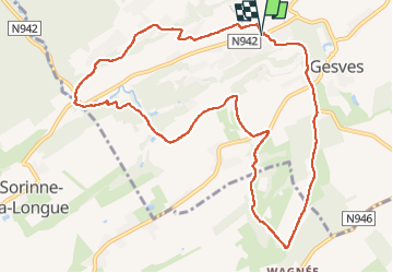

Lengte
10,6 km

Max. hoogte
284 m

Positief hoogteverschil
273 m
Km-Effort
14,2 km

Min. hoogte
189 m

Negatief hoogteverschil
272 m
Boucle
Ja
Datum van aanmaak :
2022-08-28 07:28:11.0
Laatste wijziging :
2022-08-28 09:51:55.941
2h23
Moeilijkheid : Onbekend

Gratisgps-wandelapplicatie
 SityTrail
IGN / Geografische instituten
SityTrail Plus
De wereld gaat voor u open
Over ons
Tocht Stappen van 10,6 km beschikbaar op Wallonië, Namen, Gesves. Deze tocht wordt voorgesteld door thomarche.
Beschrijving
Belle boucle. Sentiers, vues, varié. Peu macadam peu fréquenté
Plaatsbepaling
Land:
Belgium
Regio :
Wallonië
Departement/Provincie :
Namen
Gemeente :
Gesves
Locatie:
Unknown
Vertrek:(Dec)
Vertrek:(UTM)
646786 ; 5585841 (31U) N.
Opmerkingen