


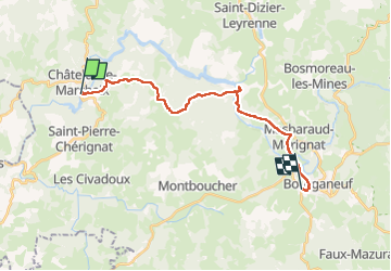
Chatelus à Bourganeuf

Nono55
Gebruiker

Lengte
19,6 km

Max. hoogte
618 m

Positief hoogteverschil
547 m
Km-Effort
27 km

Min. hoogte
328 m

Negatief hoogteverschil
467 m
Boucle
Neen
Datum van aanmaak :
2022-09-01 06:31:15.0
Laatste wijziging :
2022-09-01 14:52:30.991
5h25
Moeilijkheid : Moeilijk

Gratisgps-wandelapplicatie
 SityTrail
IGN / Geografische instituten
SityTrail Plus
De wereld gaat voor u open
Over ons
Tocht Stappen van 19,6 km beschikbaar op Nieuw-Aquitanië, Creuse, Châtelus-le-Marcheix. Deze tocht wordt voorgesteld door Nono55.
Beschrijving
Départ montée difficile à froid mais beau chemin puis après beaucoup de descente
Attention descente de cailloux avant Bourganeuf
Plaatsbepaling
Land:
France
Regio :
Nieuw-Aquitanië
Departement/Provincie :
Creuse
Gemeente :
Châtelus-le-Marcheix
Locatie:
Unknown
Vertrek:(Dec)
Vertrek:(UTM)
392117 ; 5094357 (31T) N.
Opmerkingen