


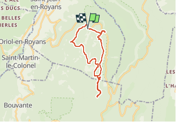
col de l'Echarasson. Lrs yeux de Miroflée.

LydiaMich
Gebruiker

Lengte
13,6 km

Max. hoogte
1167 m

Positief hoogteverschil
518 m
Km-Effort
21 km

Min. hoogte
824 m

Negatief hoogteverschil
515 m
Boucle
Ja
Datum van aanmaak :
2022-09-11 07:16:43.078
Laatste wijziging :
2022-09-11 13:09:03.649
3h56
Moeilijkheid : Gemakkelijk

Gratisgps-wandelapplicatie
 SityTrail
IGN / Geografische instituten
SityTrail Plus
De wereld gaat voor u open
Over ons
Tocht Stappen van 13,6 km beschikbaar op Auvergne-Rhône-Alpes, Drôme, Saint-Jean-en-Royans. Deze tocht wordt voorgesteld door LydiaMich .
Plaatsbepaling
Land:
France
Regio :
Auvergne-Rhône-Alpes
Departement/Provincie :
Drôme
Gemeente :
Saint-Jean-en-Royans
Locatie:
Unknown
Vertrek:(Dec)
Vertrek:(UTM)
682864 ; 4985918 (31T) N.
Opmerkingen