Tocht Stappen Mettet - Oret Wagnée DEPS  - Photo

Oret Wagnée DEPS

 thomarche
thomarche

Gebruiker

© OpenStreetMap contributors
Lengte
Lengte
10,7 km
Max. hoogte
Max. hoogte
277 m
Positief hoogteverschil
179 m
Km-Effort
Km-Effort  
13,1 km
Min. hoogte
Min. hoogte
209 m
Negatief hoogteverschil
179 m
Boucle
Boucle
Ja
Datum van aanmaak :
2022-09-18 11:02:28.0
Laatste wijziging :
2022-09-18 13:26:08.873

(0 Bericht)

Stappen
Stappen
2h23
Moeilijkheid : Heel gemakkelijk

Scan deze QR-code om de tocht te openen in de SityTrail-applicatie

Gratisgps-wandelapplicatie

Logo SityTrail SityTrail

IGN / Geografische instituten

SityTrail uit de App Store downloaden SityTrail uit Google Play downloaden

Logo SityTrail SityTrail Plus

De wereld gaat voor u open

SityTrail uit de App Store downloaden SityTrail uit Google Play downloaden SityTrail op Huawei AppGallery downloaden

Over ons

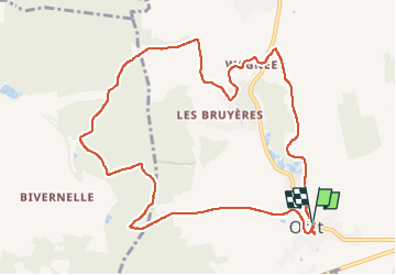
Tocht Stappen van 10,7 km beschikbaar op Wallonië, Namen, Mettet. Deze tocht wordt voorgesteld door thomarche.

Beschrijving

Très belle boucle à partir Centre village. Magnifiques chemins, différentes vues, bois, champs, pâtures. Très peu macadam très peu fréquenté. Et tout à fait ok par temps pluie (chemins très bien drainés)

Hoogteprofiel

Plaatsbepaling

Land:
Belgium
Regio :
Wallonië
Departement/Provincie :
Namen
Gemeente :
Mettet
Locatie:
Unknown
Vertrek:(Dec)
Vertrek:(UTM)
615148 ; 5573319 (31U) N.


Sluiten
Mijn abonnementen