


2022-09-14-02

Laurent53
Gebruiker
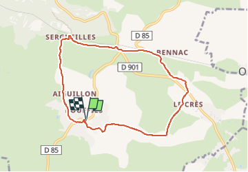

Lengte
8,2 km

Max. hoogte
588 m

Positief hoogteverschil
145 m
Km-Effort
10,1 km

Min. hoogte
514 m

Negatief hoogteverschil
146 m
Boucle
Ja
Datum van aanmaak :
2022-09-18 15:03:39.798
Laatste wijziging :
2022-09-18 16:05:48.513
2h17
Moeilijkheid : Gemakkelijk

Gratisgps-wandelapplicatie
 SityTrail
IGN / Geografische instituten
SityTrail Plus
De wereld gaat voor u open
Over ons
Tocht Te voet van 8,2 km beschikbaar op Occitanië, Aveyron, Salles-la-Source. Deze tocht wordt voorgesteld door Laurent53.
Plaatsbepaling
Land:
France
Regio :
Occitanië
Departement/Provincie :
Aveyron
Gemeente :
Salles-la-Source
Locatie:
Unknown
Vertrek:(Dec)
Vertrek:(UTM)
462040 ; 4917580 (31T) N.
Opmerkingen