


école 1 1h04

stef789
Gebruiker GUIDE
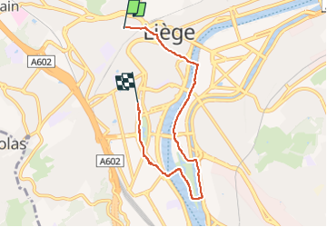

Lengte
5,4 km

Max. hoogte
88 m

Positief hoogteverschil
58 m
Km-Effort
6,2 km

Min. hoogte
43 m

Negatief hoogteverschil
78 m
Boucle
Neen
Datum van aanmaak :
2022-09-22 08:27:52.007
Laatste wijziging :
2022-09-22 09:34:59.805
1h05
Moeilijkheid : Heel gemakkelijk

Gratisgps-wandelapplicatie
 SityTrail
IGN / Geografische instituten
SityTrail Plus
De wereld gaat voor u open
Over ons
Tocht Stappen van 5,4 km beschikbaar op Wallonië, Luik, Luik. Deze tocht wordt voorgesteld door stef789.
Plaatsbepaling
Land:
Belgium
Regio :
Wallonië
Departement/Provincie :
Luik
Gemeente :
Luik
Locatie:
Glain
Vertrek:(Dec)
Vertrek:(UTM)
681338 ; 5613547 (31U) N.
Opmerkingen