


VTT - Sortie Gabin

Atchoum26
Gebruiker

Lengte
15 km

Max. hoogte
342 m

Positief hoogteverschil
306 m
Km-Effort
19,1 km

Min. hoogte
143 m

Negatief hoogteverschil
306 m
Boucle
Ja
Datum van aanmaak :
2022-10-04 07:35:19.89
Laatste wijziging :
2022-10-04 09:25:06.723
1h49
Moeilijkheid : Gemakkelijk

Gratisgps-wandelapplicatie
 SityTrail
IGN / Geografische instituten
SityTrail Plus
De wereld gaat voor u open
Over ons
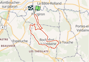
Tocht Mountainbike van 15 km beschikbaar op Auvergne-Rhône-Alpes, Drôme, Puygiron. Deze tocht wordt voorgesteld door Atchoum26.
Beschrijving
compliqué au-dessus de Rochefort au retour.
Plaatsbepaling
Land:
France
Regio :
Auvergne-Rhône-Alpes
Departement/Provincie :
Drôme
Gemeente :
Puygiron
Locatie:
Unknown
Vertrek:(Dec)
Vertrek:(UTM)
646436 ; 4933873 (31T) N.
Opmerkingen