


Abbaye de l'Etanche depuis Hattonchatel

kikkko
Gebruiker
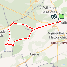

Lengte
14,5 km

Max. hoogte
414 m

Positief hoogteverschil
245 m
Km-Effort
17,8 km

Min. hoogte
273 m

Negatief hoogteverschil
246 m
Boucle
Ja
Datum van aanmaak :
2014-12-10 00:00:00.0
Laatste wijziging :
2014-12-10 00:00:00.0
1h52
Moeilijkheid : Medium

Gratisgps-wandelapplicatie
 SityTrail
IGN / Geografische instituten
SityTrail Plus
De wereld gaat voor u open
Over ons
Tocht Mountainbike van 14,5 km beschikbaar op Grand Est, Meuse, Vigneulles-lès-Hattonchâtel. Deze tocht wordt voorgesteld door kikkko.
Plaatsbepaling
Land:
France
Regio :
Grand Est
Departement/Provincie :
Meuse
Gemeente :
Vigneulles-lès-Hattonchâtel
Locatie:
Hattonchâtel
Vertrek:(Dec)
Vertrek:(UTM)
697620 ; 5430097 (31U) N.
Opmerkingen