


Val de l’Eure

fb30
Gebruiker
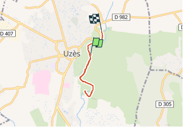

Lengte
4,6 km

Max. hoogte
91 m

Positief hoogteverschil
49 m
Km-Effort
5,3 km

Min. hoogte
69 m

Negatief hoogteverschil
53 m
Boucle
Neen
Datum van aanmaak :
2022-11-06 14:04:01.0
Laatste wijziging :
2022-11-06 15:41:06.502
1h36
Moeilijkheid : Gemakkelijk

Gratisgps-wandelapplicatie
 SityTrail
IGN / Geografische instituten
SityTrail Plus
De wereld gaat voor u open
Over ons
Tocht Stappen van 4,6 km beschikbaar op Occitanië, Gard, Uzès. Deze tocht wordt voorgesteld door fb30.
Plaatsbepaling
Land:
France
Regio :
Occitanië
Departement/Provincie :
Gard
Gemeente :
Uzès
Locatie:
Unknown
Vertrek:(Dec)
Vertrek:(UTM)
614320 ; 4874184 (31T) N.
Opmerkingen