![](/images/other/stat-length.png)
![Tocht Te voet Blieberg - Vallée de la Gueule et chai VDPH - Photo](https://media.geolcdn.com/t/1900/400/ext.pjpeg?maxdim=2&url=https%3A%2F%2Fstatic1.geolcdn.com%2Fsiteimages%2Fupload%2Ffiles%2F1545311037marcheuse_200dpi.jpg)
Vallée de la Gueule et chai VDPH
Fortmans
Gebruiker
![Lengte](/images/other/stat-length.png)
Lengte
19,9 km
![Max. hoogte](https://static1.geolcdn.com/siteimages/upload/files/1508320355ic_sort_altitude_max_24dp.png)
Max. hoogte
319 m
![Positief hoogteverschil](https://static1.geolcdn.com/siteimages/upload/files/1508320355ic_sort_den_pos_24dp.png)
Positief hoogteverschil
350 m
![Km-Effort](/images/other/stat-length.png)
Km-Effort
25 km
![Min. hoogte](https://static1.geolcdn.com/siteimages/upload/files/1508320355ic_sort_altitude_min_24dp.png)
Min. hoogte
124 m
![Negatief hoogteverschil](https://static1.geolcdn.com/siteimages/upload/files/1508320355ic_sort_den_neg_24dp.png)
Negatief hoogteverschil
344 m
![Boucle](https://static1.geolcdn.com/siteimages/upload/files/16400158638029165_repeat_loop_refresh_sync_direction_icon.png)
Boucle
Ja
Datum van aanmaak :
2022-11-03 08:57:07.094
Laatste wijziging :
2022-11-14 15:25:18.452
![Te voet](https://static1.geolcdn.com/sitytour/trail-icons/100.png)
5h34
Moeilijkheid : Medium
![Stappen](https://static1.geolcdn.com/sitytour/trail-icons/101.png)
4h37
Moeilijkheid : Moeilijk
![Scan deze QR-code om de tocht te openen in de SityTrail-applicatie](https://capi.geolives.com/qq0zvz2zws4bq2lad0pu/sitytour/trails/3456337/qr.png?size=200)
Gratisgps-wandelapplicatie
Over ons
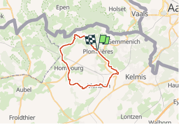
Tocht Te voet van 19,9 km beschikbaar op Wallonië, Luik, Blieberg. Deze tocht wordt voorgesteld door Fortmans.
Beschrijving
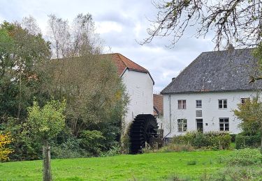
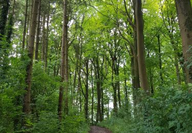
Au départ de Plombières, vallée de la Gueule jusque Moresnet, passage par Montzen, Te Berg (chai Vin du Pays de Herve), Hombourg, Sippenakken.
Alternance de bord de rivière, bois, bocages... très agréable...
Plaatsbepaling
Land:
Belgium
Regio :
Wallonië
Departement/Provincie :
Luik
Gemeente :
Blieberg
Locatie:
Unknown
Vertrek:(Dec)
Vertrek:(UTM)
708893 ; 5624859 (31U) N.
Opmerkingen
Wandeltochten in de omgeving
![Tocht Stappen Blieberg - Hombourg. Natura 2000, des sites qui valent le détour ! Lg6 - Photo](https://media.geolcdn.com/t/375/260/ext.jpg?maxdim=2&url=https%3A%2F%2Fservices.sitytrail.com%2FGeolivesWS%2FDownloadMedia.ashx%3FTrailID%3D142693%26Media%3D08dbd372-9409-44af-92fd-51b9576d1e78.JPG)
![Stappen Stappen](https://static1.geolcdn.com/sitytour/trail-icons/101.png)
Hombourg. Natura 2000, des sites qui valent le détour ! Lg6
Stappen
Gemakkelijk
(10)
Blieberg,
Wallonië,
Luik,
Belgium
![](/images/other/stat-length.png)
9,5 km | 12 km-effort
2h 35min
![](https://static1.geolcdn.com/siteimages/upload/files/16400158638029165_repeat_loop_refresh_sync_direction_icon.png)
Ja
![Tocht Stappen Kelmis - Le pays calaminaire - Photo](https://media.geolcdn.com/t/375/260/ext.jpg?maxdim=2&url=https%3A%2F%2Fmedia.geolcdn.com%2Ff%2F30655fe2-e81a-47ed-96f4-20092bed94b7.jpg)
![Stappen Stappen](https://static1.geolcdn.com/sitytour/trail-icons/101.png)
Le pays calaminaire
Stappen
Medium
(1)
Kelmis,
Wallonië,
Luik,
Belgium
![](/images/other/stat-length.png)
9,6 km | 12,1 km-effort
2h 44min
![](https://static1.geolcdn.com/siteimages/upload/files/16400158638029165_repeat_loop_refresh_sync_direction_icon.png)
Ja
![Tocht Stappen Gulpen-Wittem - Epen - Vijlen - Mechelen - Photo](https://media.geolcdn.com/t/375/260/ext.jpg?maxdim=2&url=https%3A%2F%2Fmedia.geolcdn.com%2Ff%2F5bb62a81-94e0-4aeb-8671-819fde7ee6b3.jpg)
![Stappen Stappen](https://static1.geolcdn.com/sitytour/trail-icons/101.png)
Epen - Vijlen - Mechelen
Stappen
Gemakkelijk
(1)
Gulpen-Wittem,
Limburg,
Onbekend,
Netherlands
![](/images/other/stat-length.png)
13,9 km | 17,5 km-effort
3h 9min
![](https://static1.geolcdn.com/siteimages/upload/files/16400158638029165_repeat_loop_refresh_sync_direction_icon.png)
Ja
![Tocht Stappen Kelmis - La Calamine - Photo](https://media.geolcdn.com/t/375/260/ext.jpg?maxdim=2&url=https%3A%2F%2Fmedia.geolcdn.com%2Ff%2F606e5792-434a-491a-b5eb-2bfc2ef6f1ed.jpg)
![Stappen Stappen](https://static1.geolcdn.com/sitytour/trail-icons/101.png)
La Calamine
Stappen
Gemakkelijk
(1)
Kelmis,
Wallonië,
Luik,
Belgium
![](/images/other/stat-length.png)
9,1 km | 11,6 km-effort
2h 38min
![](https://static1.geolcdn.com/siteimages/upload/files/16400158638029165_repeat_loop_refresh_sync_direction_icon.png)
Ja
![Tocht Stappen Kelmis - 2022-01-18_14h17m25_kelmis - Photo](https://media.geolcdn.com/t/375/260/ext.jpg?maxdim=2&url=https%3A%2F%2Fmedia.geolcdn.com%2Ff%2F9eea9d75-ea39-4660-b255-7d2a2255555e.jpg)
![Stappen Stappen](https://static1.geolcdn.com/sitytour/trail-icons/101.png)
2022-01-18_14h17m25_kelmis
Stappen
Gemakkelijk
(1)
Kelmis,
Wallonië,
Luik,
Belgium
![](/images/other/stat-length.png)
14,2 km | 18,4 km-effort
4h 10min
![](https://static1.geolcdn.com/siteimages/upload/files/16400158638029165_repeat_loop_refresh_sync_direction_icon.png)
Ja
![Tocht Stappen Vaals - 2021-07-14_08h55m00_1431 - Photo](https://media.geolcdn.com/t/375/260/ext.jpg?maxdim=2&url=https%3A%2F%2Fmedia.geolcdn.com%2Ff%2Fbe698cb8-a234-4803-8ecd-dfa4be54f61b.jpg)
![Stappen Stappen](https://static1.geolcdn.com/sitytour/trail-icons/101.png)
2021-07-14_08h55m00_1431
Stappen
Medium
(1)
Vaals,
Limburg,
Onbekend,
Netherlands
![](/images/other/stat-length.png)
13,1 km | 16,6 km-effort
3h 46min
![](https://static1.geolcdn.com/siteimages/upload/files/16400158638029165_repeat_loop_refresh_sync_direction_icon.png)
Ja
![Tocht Stappen Gulpen-Wittem - 2021-07-01_12h32m15_730 - Photo](https://media.geolcdn.com/t/375/260/ext.jpg?maxdim=2&url=https%3A%2F%2Fmedia.geolcdn.com%2Ff%2F6d525f96-e75b-473b-8ed3-0e3441be1b34.jpg)
![Stappen Stappen](https://static1.geolcdn.com/sitytour/trail-icons/101.png)
2021-07-01_12h32m15_730
Stappen
Gemakkelijk
(1)
Gulpen-Wittem,
Limburg,
Onbekend,
Netherlands
![](/images/other/stat-length.png)
21 km | 26 km-effort
5h 59min
![](https://static1.geolcdn.com/siteimages/upload/files/16400158638029165_repeat_loop_refresh_sync_direction_icon.png)
Ja
![Tocht Stappen Kelmis - 20200730 - Les 3 Bornes 7.3 Km - Photo](https://media.geolcdn.com/t/375/260/ext.jpg?maxdim=2&url=https%3A%2F%2Fmedia.geolcdn.com%2Ff%2Fab7b3f98-4235-4a73-ba70-1bedd5c785f3.jpg)
![Stappen Stappen](https://static1.geolcdn.com/sitytour/trail-icons/101.png)
20200730 - Les 3 Bornes 7.3 Km
Stappen
Moeilijk
(1)
Kelmis,
Wallonië,
Luik,
Belgium
![](/images/other/stat-length.png)
7,4 km | 10,4 km-effort
1h 50min
![](https://static1.geolcdn.com/siteimages/upload/files/16400158638029165_repeat_loop_refresh_sync_direction_icon.png)
Ja
![Tocht Stappen Kelmis - Venn Trilogie (1er étape) - Photo](https://media.geolcdn.com/t/375/260/ext.jpg?maxdim=2&url=https%3A%2F%2Fmedia.geolcdn.com%2Ff%2F1309a595-2e15-4d31-9259-ac0f30e3e1c8.jpg)
![Stappen Stappen](https://static1.geolcdn.com/sitytour/trail-icons/101.png)
Venn Trilogie (1er étape)
Stappen
Medium
(1)
Kelmis,
Wallonië,
Luik,
Belgium
![](/images/other/stat-length.png)
25 km | 30 km-effort
5h 0min
![](https://static1.geolcdn.com/siteimages/upload/files/16400158638029165_repeat_loop_refresh_sync_direction_icon.png)
Neen