


Croix Renard

Delhezpy
Gebruiker
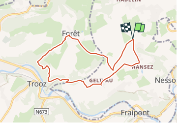

Lengte
7,9 km

Max. hoogte
258 m

Positief hoogteverschil
213 m
Km-Effort
10,7 km

Min. hoogte
140 m

Negatief hoogteverschil
213 m
Boucle
Ja
Datum van aanmaak :
2022-11-23 00:10:08.059
Laatste wijziging :
2022-11-23 00:11:08.844
2h26
Moeilijkheid : Gemakkelijk

Gratisgps-wandelapplicatie
 SityTrail
IGN / Geografische instituten
SityTrail Plus
De wereld gaat voor u open
Over ons
Tocht Stappen van 7,9 km beschikbaar op Wallonië, Luik, Olne. Deze tocht wordt voorgesteld door Delhezpy.
Plaatsbepaling
Land:
Belgium
Regio :
Wallonië
Departement/Provincie :
Luik
Gemeente :
Olne
Locatie:
Unknown
Vertrek:(Dec)
Vertrek:(UTM)
692699 ; 5606970 (31U) N.
Opmerkingen