


DANVRAI22 16:52:58

UDGI54
Gebruiker
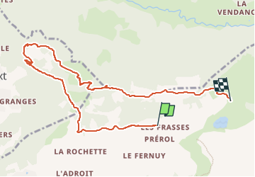

Lengte
9,9 km

Max. hoogte
1715 m

Positief hoogteverschil
513 m
Km-Effort
16,7 km

Min. hoogte
1357 m

Negatief hoogteverschil
483 m
Boucle
Neen
Datum van aanmaak :
2022-12-06 16:03:55.534
Laatste wijziging :
2022-12-06 16:03:55.534

Gratisgps-wandelapplicatie
 SityTrail
IGN / Geografische instituten
SityTrail Plus
De wereld gaat voor u open
Over ons
Tocht van 9,9 km beschikbaar op Auvergne-Rhône-Alpes, Haute-Savoie, La Clusaz. Deze tocht wordt voorgesteld door UDGI54.
Plaatsbepaling
Land:
France
Regio :
Auvergne-Rhône-Alpes
Departement/Provincie :
Haute-Savoie
Gemeente :
La Clusaz
Locatie:
Unknown
Vertrek:(Dec)
Vertrek:(UTM)
303067 ; 5087797 (32T) N.
Opmerkingen