


Nans sous sainte Anne Autour de la source du Lison

grasgilbert
Gebruiker
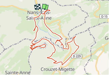

Lengte
13,5 km

Max. hoogte
692 m

Positief hoogteverschil
700 m
Km-Effort
23 km

Min. hoogte
361 m

Negatief hoogteverschil
695 m
Boucle
Ja
Datum van aanmaak :
2022-12-13 13:39:45.67
Laatste wijziging :
2022-12-13 14:28:29.844
4h17
Moeilijkheid : Moeilijk

Gratisgps-wandelapplicatie
 SityTrail
IGN / Geografische instituten
SityTrail Plus
De wereld gaat voor u open
Over ons
Tocht Stappen van 13,5 km beschikbaar op Bourgondië-Franche-Comté, Doubs, Nans-sous-Sainte-Anne. Deze tocht wordt voorgesteld door grasgilbert.
Beschrijving
cascade du Verneau
Plaatsbepaling
Land:
France
Regio :
Bourgondië-Franche-Comté
Departement/Provincie :
Doubs
Gemeente :
Nans-sous-Sainte-Anne
Locatie:
Unknown
Vertrek:(Dec)
Vertrek:(UTM)
271838 ; 5207049 (32T) N.
Opmerkingen