


coursegoules amonite

fab4u
Gebruiker
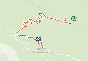

Lengte
2,5 km

Max. hoogte
1403 m

Positief hoogteverschil
14 m
Km-Effort
3,5 km

Min. hoogte
1126 m

Negatief hoogteverschil
256 m
Boucle
Neen
Datum van aanmaak :
2022-11-27 11:03:31.5
Laatste wijziging :
2022-12-23 15:13:32.697
3h58
Moeilijkheid : Gemakkelijk

Gratisgps-wandelapplicatie
 SityTrail
IGN / Geografische instituten
SityTrail Plus
De wereld gaat voor u open
Over ons
Tocht Stappen van 2,5 km beschikbaar op Provence-Alpes-Côte d'Azur, Alpes-Maritimes, Coursegoules. Deze tocht wordt voorgesteld door fab4u.
Plaatsbepaling
Land:
France
Regio :
Provence-Alpes-Côte d'Azur
Departement/Provincie :
Alpes-Maritimes
Gemeente :
Coursegoules
Locatie:
Unknown
Vertrek:(Dec)
Vertrek:(UTM)
342103 ; 4851966 (32T) N.
Opmerkingen