Tocht Stappen Bouillon - Corbion( bouillon): le sentier des points de vue - Photo

Corbion( bouillon): le sentier des points de vue

 micheldutilleul
micheldutilleul

Gebruiker

© OpenStreetMap contributors
Lengte
Lengte
8,8 km
Max. hoogte
Max. hoogte
396 m
Positief hoogteverschil
293 m
Km-Effort
Km-Effort  
12,8 km
Min. hoogte
Min. hoogte
215 m
Negatief hoogteverschil
294 m
Boucle
Boucle
Ja
Datum van aanmaak :
2022-12-30 11:43:34.764
Laatste wijziging :
2023-01-01 20:18:01.598

(0 Bericht)

Stappen
Stappen
2h32
Moeilijkheid : Medium

Scan deze QR-code om de tocht te openen in de SityTrail-applicatie

Gratisgps-wandelapplicatie

Logo SityTrail SityTrail

IGN / Geografische instituten

SityTrail uit de App Store downloaden SityTrail uit Google Play downloaden

Logo SityTrail SityTrail Plus

De wereld gaat voor u open

SityTrail uit de App Store downloaden SityTrail uit Google Play downloaden SityTrail op Huawei AppGallery downloaden

Over ons

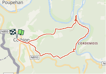
Tocht Stappen van 8,8 km beschikbaar op Wallonië, Luxemburg, Bouillon. Deze tocht wordt voorgesteld door micheldutilleul.

Beschrijving

Magnifique balade en forêt et sur les hauteurs de la Semois.
Attention, veillez prendre de bonnes chaussures de marché. Certains passages sont accidentés, voir dans l eau si la semois déborde.

Hoogteprofiel

Plaatsbepaling

Land:
Belgium
Regio :
Wallonië
Departement/Provincie :
Luxemburg
Gemeente :
Bouillon
Locatie:
Unknown
Vertrek:(UTM)
644380 ; 5518080 (31U) N.


Sluiten
Mijn abonnementen