


pisc. Louis sud

coglais
Gebruiker

Lengte
10,4 km

Max. hoogte
119 m

Positief hoogteverschil
74 m
Km-Effort
11,4 km

Min. hoogte
84 m

Negatief hoogteverschil
75 m
Boucle
Ja
Datum van aanmaak :
2017-09-26 00:00:00.0
Laatste wijziging :
2017-09-26 00:00:00.0
2h20
Moeilijkheid : Onbekend

Gratisgps-wandelapplicatie
 SityTrail
IGN / Geografische instituten
SityTrail Plus
De wereld gaat voor u open
Over ons
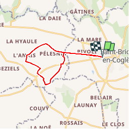
Tocht Noords wandelen van 10,4 km beschikbaar op Bretagne, Ille-et-Vilaine, Maen-Roch. Deze tocht wordt voorgesteld door coglais.
Beschrijving
départ de la piscine et boucle vers l'ouest après le Beaumier
Plaatsbepaling
Land:
France
Regio :
Bretagne
Departement/Provincie :
Ille-et-Vilaine
Gemeente :
Maen-Roch
Locatie:
Saint-Brice-en-Coglès
Vertrek:(Dec)
Vertrek:(UTM)
620295 ; 5363123 (30U) N.
Opmerkingen